


 Beyond the Board: Early Engagement Means Faster Prototyping for Defense Programs
 Defense Speak Interpreted: The Autonomous Plane Battle—Skyborg Vs. Loyal Wingman
 American Made Advocacy: Congress Back from Break With Work To Do


Major Ocean-Observing Satellite Starts Providing Science Data
June 21, 2021 | NASA JPLEstimated reading time: 3 minutes
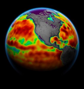
Sentinel-6 Michael Freilich, the latest spacecraft to monitor sea surface height, releases its first science measurements to users.
After six months of check-out and calibration in orbit, the Sentinel-6 Michael Freilich satellite will make its first two data streams available to the public on June 22. It launched from Vandenberg Air Force Base in California on Nov. 21, 2020, and is a U.S.-European collaboration to measure sea surface height and other key ocean features, such as ocean surface wind speed and wave height.
One of the sea surface height data streams that will be released is accurate to 2.3 inches (5.8 centimeters) and will be available within hours of when the instruments aboard Sentinel-6 Michael Freilich collect it. A second stream of data, accurate to 1.4 inches (3.5 centimeters), will be released two days after collection. The difference in when the products become available balances accuracy with delivery timeliness for tasks like forecasting the weather and helping to monitor the formation of hurricanes. More datasets, which will be accurate to about 1.2 inches (2.9 centimeters), are slated for distribution later this year and are intended for research activities and climate science including tracking global mean sea level rise.
The satellite, named after former NASA Earth Science Division Director Michael Freilich, collects its measurements for about 90% of the world’s oceans. It is one of two satellites that compose the Copernicus Sentinel-6/Jason-CS (Continuity of Service) mission. The second satellite, Sentinel-6B, is slated for launch in 2025. Together, they are the latest in a series of spacecraft starting with TOPEX/Poseidon in 1992 and continuing with the Jason series of satellites that have been gathering precise ocean height measurements for nearly 30 years.
Shortly after launch, Sentinel-6 Michael Freilich moved into position, trailing the current reference sea level satellite Jason-3 by 30 seconds. Scientists and engineers then spent time cross-calibrating the data collected by both satellites to ensure the continuity of measurements between the two. Once they have are assured of the data quality, Sentinel-6 Michael Freilich will then become the primary sea level satellite.
“It’s a relief knowing that the satellite is working and that the data look good,” said Josh Willis, project scientist at NASA’s Jet Propulsion Laboratory in Southern California. “Several months from now, Sentinel-6 Michael Freilich will take over for its predecessor, Jason-3, and this data release is the first step in that process.”
Keeping an Eye on Rising Seas
The ocean absorbs more than 90% of the heat trapped in the Earth system by increasing concentrations of greenhouse gases, which causes seawater to expand and sea level to rise. Monitoring ocean height is important because it helps forecasters predict things, including ocean currents and potential hurricane strength.
“These initial data show that Sentinel-6 Michael Freilich is an amazing new tool that will help to improve marine and weather forecasts,” said Eric Leuliette, program and project scientist at the National Oceanic and Atmospheric Administration in Maryland. “In a changing climate, it’s a great achievement that these data are ready for release.”
Ocean Altimetry Programme Manager Julia Figa Saldana of EUMETSAT (European Organisation for the Exploitation of Meteorological Satellites), added that the operational release of the first data streams from this unique ocean altimetry mission was a significant milestone at the start of the Atlantic hurricane season.
“The altimetry data are now being processed at EUMESAT headquarters in Darmstadt, from where the satellite is also being controlled, and released to ocean and weather forecasting data users around the world for their operational usage,” Saldana said.
Scientists also anticipate using the data to gauge how fast sea levels are rising because of climate change. The expansion of warm seawater accounts for about one-third of modern-day sea level rise, while meltwater from glaciers and ice sheets accounts for the rest. The rate at which the oceans are rising has accelerated over the past two decades, and researchers expect it to speed up more in the years to come. Sea level rise will change coastlines and increase flooding from tides and storms. To better understand how rising seas will impact humanity, researchers need long climate records – something Sentinel-6 Michael Freilich will help provide.
For more about Sentinel-6 Michael Freilich, visit: www.nasa.gov/sentinel-6
Share on:


Testimonial
"We’re proud to call I-Connect007 a trusted partner. Their innovative approach and industry insight made our podcast collaboration a success by connecting us with the right audience and delivering real results."
Julia McCaffrey - NCAB GroupSuggested Items
Muon Space to Integrate SpaceX’s Starlink Mini Space Lasers Into Its Halo™ Satellite Platform
10/21/2025 | Muon SpaceMuon Space, a leading end‑to‑end space systems provider specializing in mission‑optimized satellite constellations, announced an agreement with SpaceX’s Starlink to integrate its mini laser terminals into Muon’s high-performance Halo™ satellite platform.
Thales Alenia Space Inaugurates State-of-the-art Space Smart Factory
10/08/2025 | ThalesThales Alenia Space, a joint venture between Thales (67%) and Leonardo (33%), has inaugurated its Space Smart Factory in Rome with a ceremony attended by Italian President Sergio Mattarella. The factory — one of Europe’s largest intelligent, digital, reconfigurable manufacturing facilities — is located at the Tecnopolo Tiburtino high-tech innovation hub in Rome.
Septentrio, Xona Sign MOU to Accelerate Adoption of Next-Era Navigation Technology
10/07/2025 | SeptentrioSeptentrio, part of Hexagon, a leader in high-precision GNSS technology, and Xona Space Systems, pioneer in low-Earth orbit (LEO) satellite navigation, have signed a Memorandum of Understanding (MOU) to deepen their collaboration on next-generation positioning and timing solutions.
Boeing Delivers Second ViaSat‑3 Satellite to Viasat
09/30/2025 | BAE SystemsBoeing has delivered ViaSat‑3 F2, the second spacecraft in Viasat’s next‑generation, ultra‑high‑capacity constellation.
Terran Orbital Completes Delivery of Satellite Bus Platforms to Lockheed Martin for the Tranche 1 Transport Layer
09/23/2025 | BUSINESS WIRETerran Orbital Corporation, a leading manufacturer of small satellites primarily serving the aerospace and defense industries, today announced the successful delivery of all 42 satellite bus platforms for the Space Development Agency’s (SDA) Proliferated Warfighter Space Architecture Tranche 1 program.