


 The Marketing Minute: Cracking the Code of Technical Marketing
 Trouble in Your Tank: Implementing Direct Metallization in Advanced Substrate Packaging


Swarm Reveals Why Satellites Lose Track
October 31, 2016 | ESAEstimated reading time: 2 minutes
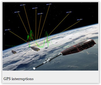
Satellite engineers have been puzzling over why GPS navigation systems on low-orbiting satellites like ESA’s Swarm sometimes black out when they fly over the equator between Africa and South America. Thanks to Swarm, it appears ‘thunderstorms’ in the ionosphere are to blame.
Launched in 2013, the Swarm trio is measuring and untangling the different magnetic fields that stem from Earth’s core, mantle, crust, oceans, ionosphere and magnetosphere – an undertaking of at least four years.
As with many satellites, ESA’s three Swarm satellites carry GPS receivers as part of their positioning system so that operators keep them in the correct orbits. In addition, GPS pinpoints where the satellites are making their scientific measurements.
However, sometimes the satellites lose their GPS connection. In fact, during their first two years in orbit, the link was broken 166 times.
A paper published recently describes how Swarm has revealed there is a direct link between these blackouts and ionospheric ‘thunderstorms’, around 300–600 km above Earth.
Claudia Stolle from the GFZ research centre in Potsdam, Germany said, “Ionospheric thunderstorms are well known, but now we have been able to show a direct link between these storms and the loss of connection to GPS.
“This is thanks to Swarm because it is the first time that high-resolution GPS and ionospheric patterns can be detected from the same satellite.”
These thunderstorms occur when the number of electrons in the ionosphere undergoes large and rapid changes. This tends to happen close to Earth’s magnetic equator and typically just for a couple of hours between sunset and midnight.
As its name suggests, the ionosphere is where atoms are broken up by sunlight, which leads to free electrons. A thunderstorm scatters these free electrons, creating small bubbles with little or no ionised material. These bubbles disturb the GPS signals so that the Swarm GPS receivers can lose track.
It transpires that 161 of the lost signal events coincided with ionospheric thunderstorms. The other five were over the polar regions and corresponded to increased strong solar winds that cause Earth’s protective magnetosphere to ‘wobble’.
Resolving the mystery of blackouts is not only good news for Swarm, but also for other low-orbiting satellites experiencing the same problem. It means that engineers can use this new knowledge to improve future GPS systems to limit signal losses.
Christian Siemes, who works at ESA on the mission, said, “In light of this new knowledge, we have been able to tune the Swarm GPS receivers so they are more robust, resulting in fewer blackouts.
“Importantly, we are able to measure variations in the GPS signal which is not only interesting for engineers developing GPS instruments, but also interesting to advance our scientific understanding of upper-atmosphere dynamics.”
ESA’s Swarm mission manager, Rune Floberghagen, added, “What we see here is a striking example of a technical challenge being turned into exciting science, a true essence of an Earth Explorer mission such as Swarm.
“These new findings demonstrate that GPS can be used as a tool for understanding dynamics in the ionosphere related to solar activity. Perhaps one day we will also be able to link these ionospheric thunderstorms with the lightning we see from the ground.”
Share on:


Testimonial
"The I-Connect007 team is outstanding—kind, responsive, and a true marketing partner. Their design team created fresh, eye-catching ads, and their editorial support polished our content to let our brand shine. Thank you all! "
Sweeney Ng - CEE PCBSuggested Items
Beyond Design: Slaying Signal Integrity Villains
09/17/2025 | Barry Olney -- Column: Beyond DesignHigh-speed PCB design is a balancing act, where subtle oversights can develop into major signal integrity nightmares. Some culprits lie dormant during early validation, only to reveal themselves later through workflow disruptions and elusive performance bottlenecks. Take crosstalk, for example. What begins as a stray signal coupling between traces can ripple through the design, ultimately destabilizing the power distribution network. Each of these troublemakers operates with signature tactics, but they also have well-known vulnerabilities.
Staying on Top of Signal Integrity Challenges
09/16/2025 | Andy Shaughnessy, Design007 MagazineOver the years, Kris Moyer has taught a variety of advanced PCB design classes, both online IPC courses and in-person classes at California State University-Sacramento, where he earned his degrees in electrical engineering. Much of his advanced curriculum focuses on signal integrity, so we asked Kris to discuss the trends he’s seeing in signal integrity today, the SI challenges facing PCB designers, and his go-to techniques for controlling or completely eliminating SI problems.
September 2025 PCB007 Magazine: The Future of Advanced Materials
09/16/2025 | I-Connect007 Editorial TeamMoore’s Law is no more, and the advanced material solutions being developed to grapple with this reality are surprising, stunning, and perhaps a bit daunting. Buckle up for a dive into advanced materials and a glimpse into the next chapters of electronics manufacturing.
Elementary Mr. Watson: Running the Signal Gauntlet
09/11/2025 | John Watson -- Column: Elementary, Mr. WatsonIf you’ve ever run a military obstacle course, you know it’s less “fun fitness challenge” and more “how can we inflict as much pain in the shortest time possible?” You start fresh—chest out, lungs full of confidence, thinking you might even look good doing this—and 10 seconds later, you’re questioning all your life choices.
The Shaughnessy Report: Winning the Signal Integrity Battle
09/09/2025 | Andy Shaughnessy -- Column: The Shaughnessy ReportWhen I first started covering this industry in 1999, signal integrity was the hip new thing in PCB design. Conference classes on signal integrity were packed to the walls, and an SI article was guaranteed to get a lot of reads.