


 The Knowledge Base: A Conference for Cleaning and Coating of Mission-critical Electronics
 Defense Speak Interpreted: Is DARPA Still Around After CHIPS?
 Beyond the Board: Orbital High Ground—Why Space Superiority Is Slipping Away


Meet the Next Generation of Industry Leading Drone LiDAR Survey Equipment from Microdrones
February 15, 2021 | Globe NewswireEstimated reading time: 1 minute
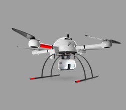
Building upon the momentum of the Microdrones as a Service (mdaaS) program launched in mid-2020 (which offers customers convenient monthly payment options for equipment and software) Microdrones is pleased to announce the newest in its lineup of drone lidar survey equipment, the mdLiDAR1000HR aaS, available as part of this program.
According to Vivien Heriard-Dubreuil, Microdrones CEO, “We have had such a positive response to our new mdaaS program, we wanted to provide our customers another option at the mid-range price point for drone based LiDAR. That’s why we enhanced our mdLiDAR1000 aaS system with the new mdLiDAR1000HR aaS. What does the HR stand for? Quite simply: high resolution.”
Dr. Nicolas Seube, Director of R&D for the Microdrones sister software company, mdInfinity, explains ““The Microdrones mdLiDAR1000HR aaS precision was analyzed by flights between 30 and 60 meters over a wide sample of surfaces (asphalt, gravel, roofs, natural ground) exhibiting different reflectance. This drone LiDAR system, with a 90 degree field of view for both scanned points and imagery, repeatedly provides a precision of 1.6 cm (.052 ft) at 1-? when flown at 40 m (130 ft) at a speed of 8 m/s (18 mph). This was confirmed by a repeatability analysis.”
Robert Chrismon, Microdrones Marketing Manager adds, “Overall, I was very impressed with the data produced by the new mdLiDAR1000HR aaS, and excited to see the resolution improvement over the mdLiDAR1000 aaS. With the additional point density, greater resolution, and higher accuracy over the previous mdLiDAR1000 aaS, we start to close the gap on the mdLiDAR3000 aaS. This will allow more of the surveying community access to a quality UAV LiDAR solution.”
Company COO Frank Darmayan says, “We worked with LiDAR innovator Velodyne to seamlessly integrate their Puck Lite sensor. It’s lightweight, it offers increased range as well as field of view. When you combine that with our complete package of software, workflow, service and support, you have a turnkey drone lidar system that improves your field data collection and data processing productivity on day one… and surveyors can choose easy monthly payments or traditional purchasing options… whatever works best for them.”
Share on:


Suggested Items
Microchip Expands Space-Qualified FPGA Portfolio with New RT PolarFire® Device Qualifications and SoC Availability
07/10/2025 | MicrochipContinuing to support the evolving needs of space system developers, Microchip Technology has announced two new milestones for its Radiation-Tolerant (RT) PolarFire® technology: MIL-STD-883 Class B and QML Class Q qualification of the RT PolarFire RTPF500ZT FPGA and availability of engineering samples for the RT PolarFire System-on-Chip (SoC) FPGA.
OSI Systems Lands $17 Million Order for Cargo and Vehicle Inspection Systems
07/07/2025 | BUSINESS WIREOSI Systems, Inc. announced that its Security division received an order valued at approximately $17 million from an international customer for cargo and vehicle inspection systems.
KYOCERA AVX Releases New 3DB Hybrid Couplers
07/04/2025 | PRNewswireKYOCERA AVX, a leading global manufacturer of advanced electronic components engineered to accelerate technological innovation and build a better future, released a new line of integrated thin film (ITF) hybrid couplers designed to facilitate the continued evolution of high-frequency wireless systems in industrial, automotive, telecommunications, and telemetry applications.
Accenture Acquires SYSTEMA to Drive Manufacturing Automation for Semiconductor Clients
07/02/2025 | AccentureAccenture has acquired SYSTEMA, a provider of software solutions and consulting services for manufacturing automation, headquartered in Dresden, Germany.
Driving Innovation: Direct Imaging vs. Conventional Exposure
07/01/2025 | Simon Khesin -- Column: Driving InnovationMy first camera used Kodak film. I even experimented with developing photos in the bathroom, though I usually dropped the film off at a Kodak center and received the prints two weeks later, only to discover that some images were out of focus or poorly framed. Today, every smartphone contains a high-quality camera capable of producing stunning images instantly.