


 The Chemical Connection: Back to Basic Cupric Chloride Etching
 The Marketing Minute: The Tyranny of the Dashboard
 Trouble in Your Tank: At 40 GHz, Everything Matters, Part 1


Raytheon, an RTX business, was awarded a $506 million contract from NASA to design and build the Landsat Next Instrument Suite (LandIS), which includes three next generation space instruments, with an option for an additional instrument.
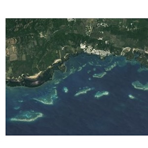
The instrument suite will perform Earth observation from three identical observatories from Low-Earth orbit. Through multispectral imaging technology, LandIS will collect images of the Earth's surface every six days, detecting natural and human-induced changes.
"The next-generation instruments for Landsat Next will ensure continuity of the longest space-based record of Earth's land surface," said Sandy Brown, vice president for Mission Solutions & Payloads for Raytheon. "With up to three times the spatial, temporal, and spectral resolution of its predecessor, the imagers will enhance data collection to improve awareness of water quality, crop production, soil conservation, forest management, mineral mapping, and climate change impacts."
Data from Landsat Next and the LandIS sensors will offer critical information about land use, crop production, weather activities, and natural resources. The next generation instrument will help to identify patterns that may have been missed in prior missions due to timing of image collection or image fidelity, helping agencies to respond to natural disasters, human migration, and environmental disasters.
Since the 1970s, Raytheon has supported the Landsat mission. In 1972, the company built the Multi Spectral Scanner (MSS), launched on the Earth Resources Technology Satellite, later renamed Landsat 1. In addition, Raytheon built the instruments for Landsat missions 2 through 7.
The first LandIS sensor is expected be delivered in 2028. Work on this contract will be performed in El Segundo, California.


