


 Trouble in Your Tank: Understanding Interconnect Defects, Part 1
 It’s Only Common Sense: Marketing Isn’t Fluff, It’s Ammunition
 Driving Innovation: Mechanical and Optical Processes During Rigid-flex Production


New Satellites Open up Further Opportunities
December 13, 2016 | Helmholtz-AssociationEstimated reading time: 3 minutes
To measure biodiversity, researchers have been using various methods of remote sensing for about 30 years in addition to traditional field studies. Under the auspices of UFZ scientists, an international team of researchers present current opportunities, developments and prospects of remote sensing in the journal Ecological Indicators and highlight its enormous potential in assisting future biodiversity research.
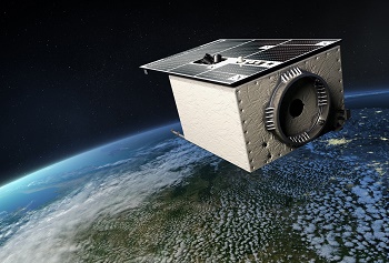
EnMAP is a German hyperspectral satellite mission for earth observation. Imaging spectrometers measure the solar radiation reflected by the earth's surface from visible light right through to shortwave infrared. These allow statements to be made regarding the state of the earth's surface and any visible changes. The mission is due to be launched in 2018 and will continue for five years.
The consequences of climate change are evidenced, inter alia, by changes in biodiversity. A key task of biodiversity research is to record the current situation, study processes within ecosystems and identify possible changes as well as disturbances. "To do this we need reliable data across large areas and close periods of time," says UFZ Landscape Ecologist PD Dr. Angela Lausch. "Various remote sensing methods already meet these requirements in a remarkable way." By using satellite images, the distribution of a plant species to be studied can, for example, be determined based on its growth habit, leaf shape, leaf geometry, phenology or flower colour - over large areas and over time. In addition, satellites are equipped with spectral sensors which help to distinguish and record plant species or plant communities based on their specific biochemical properties (chlorophyll, cellulose, leaf water content or protein content, etc.).
Depending on the question being studied, the methods of remote sensing generally vary in their capability to measure biological diversity. When choosing the method, it must always be considered whether the remote sensing sensor can actually measure the selected key parameters - that is, whether the spectral, spatial or temporal resolution is adequate in answering the question and what conclusions can be derived from this for biodiversity research. "Looking ahead, it is therefore essential that biologists, ecologists, geographers and remote sensing specialists cooperate more closely than has previously been the case and become better acquainted with the discourse of others," says UFZ biodiversity researcher Prof. Josef Settele, co-author of the study. The traits of plants, animals, water and soil are what links remote sensing to other disciplines," adds Lausch.
The hyperspectral satellite EnMAP (Environmental Mapping and Analysis Program) is due to be launched in 2018 and will provide image data with very high spectral resolution. Hyperspectral remote sensing could then be used to measure many more biochemical parameters, such as nitrogen, phosphate or the water content in leaf tissue. "EnMAP will significantly improve the identification of species and plant communities via remote sensing. However, the greatest potential offered by hyperspectral remote sensing lies in measuring processes and disturbances within ecosystems over large areas," says Lausch. "The data produced by the EnMAP satellite will be freely available to all users. We, in biodiversity research, should therefore be prepared to recognise and leverage the potential of the new generation of satellites."
However, we will still need field studies, where samples are collected, species and plant communities recorded and ecosystem processes - such as photosynthesis activity or the ability to bind carbon - are identified. Unlike remote sensing, they only represent a local and temporary sample and are also time-consuming, costly and usually tedious to evaluate. However, they provide crucial information that cannot be recorded via remote sensing - such as information on ecological potency, stress behaviour and the adaptability of species and plant communities. In addition, they are indispensable for evaluating and interpreting remote sensing data. "One is not possible without the other," says Lausch. "Biodiversity can only be measured more accurately than before and processes, including their changes and disturbances, mapped on various spatial and temporal scales by combining in-situ studies and remote sensing."
However, in terms of practical implementation, there are still a few stumbling blocks, says Lausch. A typical stumbling block is the fact that worldwide there are still very few uniform standards dedicated to measuring biodiversity data. In addition, the link between field and remote sensing data must be optimised so that it is easier to aggregate large, complex and heterogeneous data volumes and data can be more easily evaluated and transferred to models.
A key step in this direction is the so-called "Essential Biodiversity Variables" (EBV), the development of which has been possible due to the efforts of scientists such as Angela Lausch and many of her co-authors worldwide.
Share on:


Testimonial
"In a year when every marketing dollar mattered, I chose to keep I-Connect007 in our 2025 plan. Their commitment to high-quality, insightful content aligns with Koh Young’s values and helps readers navigate a changing industry. "
Brent Fischthal - Koh YoungSuggested Items
SEMI Reports Global Silicon Wafer Shipments to Rebound 5.4% in 2025, with New Record Expected by 2028
10/30/2025 | SEMIGlobal shipments of silicon wafers are projected to increase 5.4% in 2025 to 12,824 million square inches (MSI) followed by steady growth through 2028 when the market is expected to reach a new industry record of 15,485 MSI, SEMI reported in its annual silicon shipment forecast.
productronica 2025: iTAC Presents AI-supported Knowledge Platform for Connected Production
10/29/2025 | iTAC Software AGIn modern manufacturing facilities, valuable knowledge is stored in systems, documents, and the minds of employees – often fragmented, isolated, and not centrally available.
Unlocking the Promise of AI in Electronics Manufacturing
10/29/2025 | Shobhit Agrawal, Keysight TechnologiesThe electronics manufacturing industry is rapidly evolving as more complicated products are introduced in the production lines, which require technological advancements even in the production processes. The requirements for production that is efficient, product quality that is greater, and product life cycles that are shorter are more crucial than ever before. In the electronic device life cycle, from design to maintenance, test phases have a significant impact on the economy of the company. Test processes are closely linked to the production volume and impacted by the complexity of the product. For businesses to maintain their competitive edge, they need to adopt innovative solutions and redefine processes.
Better Sustainability Policies for Electronics
10/29/2025 | Diana Radovan, Global Electronics AssociationI joined the Global Electronics Association in August 2025 as the director of sustainability policy. Since then, much has happened in terms of geopolitics and in the development and re-envisioning of sustainability policies in the industry. While the European Commission has released several legislative packages to simplify sustainability requirements (“omnibus”), these developments haven’t yet settled and are not in effect. Given the many recent and ongoing public consultations, with often conflicting input from a broad range of stakeholders, final negotiations remain rather polarized among policymakers.
SEMI Reports Global Silicon Wafer Shipments to Rebound 5.4% in 2025, with New Record Expected by 2028
10/29/2025 | SEMIGlobal shipments of silicon wafers are projected to increase 5.4% in 2025 to 12,824 million square inches (MSI) followed by steady growth through 2028 when the market is expected to reach a new industry record of 15,485 MSI, SEMI reported today in its annual silicon shipment forecast.