


 Trouble in Your Tank: Understanding Interconnect Defects, Part 1
 It’s Only Common Sense: Marketing Isn’t Fluff, It’s Ammunition
 Driving Innovation: Mechanical and Optical Processes During Rigid-flex Production


New Drone to Ensure Safer Demining
December 20, 2016 | DTUEstimated reading time: 3 minutes
Researchers at DTU intend to develop a drone with magnetometers capable of mapping mines in former war zones, which will make demining more efficient and less dangerous. The project has received DKK 11 million from Innovation Fund Denmark.
Mines are usually made of magnetic steel, and the search for mines therefore often involves ‘magnetometers’—instruments capable of measuring minor magnetic deviations in the subsurface and thereby localizing the mines.
“The plan is for our drone and its unique magnetometer module to make demining more precise than the current method of using off-road vehicles on land and special divers in coastal areas. It will also minimize the risk of injuries for the people involved, as the drone can be operated from a safe position outside the mined areas,” explains Arne Døssing, Senior Research, DTU Space, who heads the project of developing the new technology.
He also believes that the new demining system could reduce the costs and time of mapping the presence of mines by more than 50 per cent.
A unique system
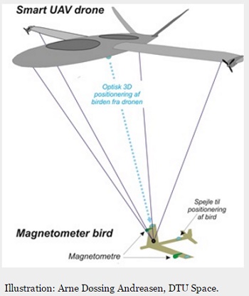
Arne Døssing is the originator of the idea to develop the new demining system consisting of a newly developed drone type with a frame installed underneath it, which will be specially developed by DTU Space researchers. The frame is referred to as a ‘magnetometer bird’, as the magnetometer is embedded in the frame, which is attached to the drone and hangs approx. 5-10 metres below it.
“It will be the first drone in the world to fly with a ‘bird’ underneath it. This construction is absolutely necessary to ensure the ultra-sensitive magnetometers are as close to the surface as possible, at the same time as minimizing exposure to magnetic disturbances from other instruments and from the flying drone,” says Arne Døssing.
For the same reason, the equipment designed to measure the exact position of the drone—and thus of the detected mines—is installed in the drone rather than in the ‘bird’. This takes place in close collaboration between DTU researchers and the Danish drone company Sky-Watch A/S.
The drone itself is also an innovation. It has been developed by Sky-Watch, and in addition to the ability to fly like a regular aircraft, it allows for vertical take-off and landing in the same way as a helicopter.
Great interest in efficient demining
Initially, the researchers will be focusing on the need to clear mines from World War II, before laying power cables to new offshore wind turbines. It is assumed that the number of unexploded mines from World War II hidden in the sea and on land exceeds 40,000.
Therefore, there are several parties involved in the project which are interested in applying the new technology. In addition to the drone company Sky-Watch A/S, DONG Energy is establishing many new offshore wind farms, Geo is carrying out geotechnical surveys in connection with, for example, offshore wind farms, and the Royal Danish Navy’s mine clearance service often has the dangerous task of clearing the mines.
The magnetometer drone will furthermore be tested in the mountains of Greenland, where it may have an impact on the search for mineral deposits or military waste, and it will also be tested from a vessel in relation to its ability to detect large mines in deeper waters. In both cases, the drone’s ability to take off and land vertically is significant.
Denmark to take a leading role in magnetic mapping
Over the next four years, researchers from DTU Space will develop and test the new technology. The hope is that in the long term, the technology can supplement the existing mine detection technologies, which are both expensive and inefficient. This could potentially give Denmark a leading position in relation to magnetic mapping of the subsurface.
“The global market for flexible, efficient, and precise mapping of, for instance, mines, military waste, and minerals is big. So the project will allow Danish technology companies to take a strong position in this area,” says Arne Døssing.
Share on:


Testimonial
"The I-Connect007 team is outstanding—kind, responsive, and a true marketing partner. Their design team created fresh, eye-catching ads, and their editorial support polished our content to let our brand shine. Thank you all! "
Sweeney Ng - CEE PCBSuggested Items
GlobalFoundries, Silicon Labs Expand Partnership to Accelerate Wireless Connectivity Solutions and Strengthen U.S. Chip Manufacturing
11/05/2025 | GlobalFoundriesGlobalFoundries (GF), one of the world’s leading semiconductor manufacturers, and Silicon Labs, the leading innovator in low-power wireless, announced the expansion of their strategic partnership to advance the development of next-generation, energy-efficient wireless technologies and scale U.S.-based semiconductor manufacturing.
Learning With Leo: UHDI—The Next Leap in PCB Manufacturing
11/05/2025 | Leo Lambert -- Column: Learning With LeoHigh density interconnect (HDI) technology has been a cornerstone of miniaturized electronics since Hewlett-Packard introduced the first chip-scale implementation in 1982. Over time, HDI processes became central to organic flip-chip packaging in the semiconductor industry. Today, the convergence of IC substrates and system-level PCBs has accelerated the adoption of UHDI.
On the Line With… Ultra HDI, Episode 8: “Materials, Up and Coming Capabilities,” Now Available
11/05/2025 | I-Connect007I-Connect007 is excited to announce the release of the eighth episode of its 12-part podcast series, On the Line With… American Standard Circuits: Ultra HDI. In this episode, “Materials, Up and Coming Capabilities,” host Nolan Johnson sits down with resident expert John Johnson, Director of Quality and Advanced Technology at American Standard Circuits, to discuss how material selection influences the Ultra HDI (UHDI) manufacturing process.
High Density Packaging User Group Announces ASKPCB Membership
11/03/2025 | HDP User GroupHigh Density Packaging User Group (HDP) is pleased to announce that the Aoshikang Technology (Hong Kong) Co., Ltd (ASKPCB) has become a member.
Cephia Secures $4M Seed Funding to Revolutionize Multimodal Sensing with Metasurface Technology
10/31/2025 | PRNewswireCephia, a startup building products using advanced AI computational imaging technologies and silicon sensors made from advanced metamaterials, formally launched with several pilot customers and $4 million in seed venture capital funding.