


 The Government Circuit: Driving Resiliency and Economic Security on Both Sides of the Atlantic
 American Made Advocacy: Taking the Fight to Capitol Hill
 Defense Speak Interpreted: SWaPing Nanosatellites for Defense Systems
Meet the Next Generation of Industry Leading Drone LiDAR Survey Equipment from Microdrones
February 15, 2021 | Globe NewswireEstimated reading time: 1 minute
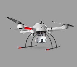
Building upon the momentum of the Microdrones as a Service (mdaaS) program launched in mid-2020 (which offers customers convenient monthly payment options for equipment and software) Microdrones is pleased to announce the newest in its lineup of drone lidar survey equipment, the mdLiDAR1000HR aaS, available as part of this program.
According to Vivien Heriard-Dubreuil, Microdrones CEO, “We have had such a positive response to our new mdaaS program, we wanted to provide our customers another option at the mid-range price point for drone based LiDAR. That’s why we enhanced our mdLiDAR1000 aaS system with the new mdLiDAR1000HR aaS. What does the HR stand for? Quite simply: high resolution.”
Dr. Nicolas Seube, Director of R&D for the Microdrones sister software company, mdInfinity, explains ““The Microdrones mdLiDAR1000HR aaS precision was analyzed by flights between 30 and 60 meters over a wide sample of surfaces (asphalt, gravel, roofs, natural ground) exhibiting different reflectance. This drone LiDAR system, with a 90 degree field of view for both scanned points and imagery, repeatedly provides a precision of 1.6 cm (.052 ft) at 1-? when flown at 40 m (130 ft) at a speed of 8 m/s (18 mph). This was confirmed by a repeatability analysis.”
Robert Chrismon, Microdrones Marketing Manager adds, “Overall, I was very impressed with the data produced by the new mdLiDAR1000HR aaS, and excited to see the resolution improvement over the mdLiDAR1000 aaS. With the additional point density, greater resolution, and higher accuracy over the previous mdLiDAR1000 aaS, we start to close the gap on the mdLiDAR3000 aaS. This will allow more of the surveying community access to a quality UAV LiDAR solution.”
Company COO Frank Darmayan says, “We worked with LiDAR innovator Velodyne to seamlessly integrate their Puck Lite sensor. It’s lightweight, it offers increased range as well as field of view. When you combine that with our complete package of software, workflow, service and support, you have a turnkey drone lidar system that improves your field data collection and data processing productivity on day one… and surveyors can choose easy monthly payments or traditional purchasing options… whatever works best for them.”
Share on:


Suggested Items
Real Time with… IPC APEX EXPO 2024: Sigma Engineering's Recycling and Regeneration Systems for PCB Etching
05/02/2024 | Real Time with...IPC APEX EXPOEvan Howard of Schmoll America interviews Kristoffer Bjorklund, Sigma Engineering's supply chain manager. We learn about Sigma's recycling and regeneration systems for PCB industry etching and the benefits and challenges of implementing these systems in existing factories.
Boeing T-7A Red Hawk Triples Progress
05/01/2024 | BoeingThe Boeing T-7A Red Hawk achieved three recent milestones, propelling the advanced pilot trainer for the U.S. Air Force forward.
Merlin Flex invests in New Schmoll Direct Imaging System
04/30/2024 | Merlin Flex LtdMerlin Flex has fully installed and commissioned its 2nd Schmoll MDI Direct Imaging system. This new machine includes a twin bed, 4 head system which enhances Merlin Flex’s direct imaging capability for its 1.4M long flexible circuits.
Latest Test and Inspection Solutions from GOEPEL electronic at SMTconnect 2024
04/29/2024 | GOEPEL electronicGOEPEL electronic will be demonstrating automated test and inspection equipment at SMTconnect, taking place in Nuremberg from June 11 to 13, 2024.
TSMC Celebrates 30th North America Technology Symposium
04/29/2024 | TSMCTSMC unveiled its newest semiconductor process, advanced packaging, and 3D IC technologies for powering the next generation of AI innovations with silicon leadership at the Company’s 2024 North America Technology Symposium.