


 It’s Only Common Sense: The Phone Is Still Mightier Than the Keyboard
 The Marketing Minute: Marketing With Layers


NEC Technology Reliably Measures Sea Levels from a Greater Distance
July 16, 2024 | JCN NewswireEstimated reading time: 2 minutes
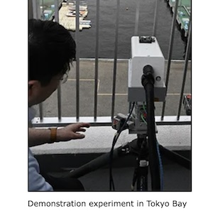
NEC Corporation has developed a technology for measuring sea levels with high accuracy from greater distances using 3D Light Detection And Ranging (LiDAR), a remote sensing technology. This technology makes it possible to reliably measure sea levels, even in the event of a tsunami or ground movement at the location where the measuring equipment is installed. In June 2024, NEC conducted a demonstration test of this technology in Tokyo Bay and confirmed that it can measure sea levels with high accuracy from a greater distance than conventional technologies.
Background
In the event of a tsunami caused by an earthquake, volcanic eruption, or other phenomenon, immediate and accurate assessment of changes in sea levels is critical to saving lives. Current radio wave and float-type sea level measurement systems have a measurement range of about 20 meters from the surface of the sea. However, if ground movement occurs due to an earthquake or other phenomenon, it becomes difficult to measure sea levels. In fact, ground movement due to a major earthquake that occurred on the Noto Peninsula of Japan in January 2024 disabled measurement equipment along part of the coastline, resulting in a delay before reliable measurements could be resumed.
About the New Technology
This new technology delivers 3D-LiDAR infrared laser beams to buoys floating on the sea, and reflected light is used to measure the distance. This ultra-sensitive optical reception is accomplished using long-range 3D-LiDAR with advanced long-range, large-capacity optical transmission and reception technology (coherent reception technology), making it possible to obtain the 3D point cloud data of objects from greater distances. As a result, this is the first time that sea levels have been successfully measured from a distance of 60 meters from the sea with an error of about 2cm. In addition, a 3D water level measurement technology has been developed that clusters processing of the acquired 3D point cloud data, classifies the shape of buoys and surrounding topography with high precision, and then compares the information to correct the position and estimate the height of buoys. This makes it possible to measure from a variety of locations and angles, meaning that 3D-LiDAR equipment can be installed in a wider variety of locations.
3D point cloud data scanned by 3D-LiDAR
As a result, tide stations may be installed in locations along the coastline that are less susceptible to significant ground movement, making the system disaster-resistant and enabling continuous monitoring of sea levels. In addition, the equipment is portable and may be flexibly installed across a wide range of locations, helping to reduce installation costs and time.
Future Developments
Going forward, NEC plans to continue developing this technology, including extending the measurable distance to several hundred meters and improving measurement accuracy by comparing 3D-LiDAR data with map information of the surrounding area, aiming for practical application by the end of FY2025.
Share on:


Testimonial
"We’re proud to call I-Connect007 a trusted partner. Their innovative approach and industry insight made our podcast collaboration a success by connecting us with the right audience and delivering real results."
Julia McCaffrey - NCAB GroupSuggested Items
RTX's Raytheon Begins Initial Production of SharpSight Surveillance Radar
10/13/2025 | RTXRaytheon, an RTX business, has launched the initial production of its new SharpSight multi-domain surveillance radar.
SEALSQ, Kaynes SemiCon Announce Joint Venture to Establish India's First Secure Semiconductor Center
09/30/2025 | Globe NewswireSEALSQ Corp, a company that focuses on developing and selling Semiconductors, PKI, and Post-Quantum technology hardware and software products,, a subsidiary of WISeKey International Holding AG , a global leader in cybersecurity, digital identity, and IoT solutions platform, announced the signing of a Term Sheet with Kaynes SemiCon to form a Joint Venture company, SEALKAYNESQ Ltd, to be established in India.
HPE Now Powers New AI-Ready Supercomputer Set to Transform Environmental Forecasting in New Zealand
09/22/2025 | BUSINESS WIREHPE announced that Earth Sciences New Zealand (formally NIWA) of Aotearoa (New Zealand) selected HPE Cray XD2000, purpose-built for AI and simulation workloads, to accelerate the organization’s environmental science and precision of meteorological forecasting.
Henger Showcases Breakthrough Plasma Technology at 2025 THECA Show
09/22/2025 | HengerThe 2025 Thailand Electronic Circuit Asia Exhibition (THECA Show) was successfully convened from August 20 to 22 at the Bangkok International Trade & Exhibition Centre (BITEC). Zhuhai Henger Microelectronic Equipment Co., Ltd. delivered a particularly notable presentation at this exhibition, comprehensively demonstrating the company's latest advancements in the field of high-end plasma equipment.
Pentalogix Launches ViewMate Essentials to Ensure PCB Designs are Manufacturing-Ready
09/03/2025 | PentaLogixPentalogix, Inc., a leader in PCB design solutions, announced the launch of ViewMate Essentials, an advanced CAM package designed to enhance the workflow of PCB designers. Available starting September 2nd, 2025, ViewMate Essentials enables designers to view, edit, and manage PCB manufacturing files with exceptional precision, facilitating seamless collaboration with PCB fabricators and assemblers.