


 It’s Only Common Sense: Stay Curious, My Friends
 The Marketing Minute: AI Is Watching Your Marketing Habits


NASA and Google broadened an existing partnership to help local governments improve their monitoring and prediction of air quality for better decision making. The expanded collaboration looks to develop advanced machine learning-based algorithms that link NASA data with Google Earth Engine data streams to generate high-resolution air quality maps in near real-time.
“We're thrilled about our partnership with NASA to make daily air quality more actionable at a local level,” said Rebecca Moore, director at Google Earth, Earth Engine and Outreach at Google.
“Environmental insights, like high resolution air quality maps, can be useful tools for cities and community organizations who can take action on climate and health in their neighborhoods,” Moore said. “This scientific research partnership with NASA will help us improve the resolution, validation and the usefulness, of air quality maps in both space and time -- giving everyone more data for decisions towards cleaner air”
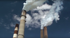
Harmful air pollution affects people and the environment and according to the World Health Organization, air pollution is responsible for about 7 million deaths worldwide each year.
“The World Bank has estimated that the global cost of health damages from air pollution is $8.1 trillion, with people in low- and middle-income countries most affected,” said Christoph Keller. He is a Morgan State University senior research scientist who works with NASA's Goddard Space Flight Center and is the lead developer of the GEOS Composition Forecasting (GEOS-CF) system. “Mitigating these impacts requires free access to high-quality, high-resolution air quality information in near real-time, which this partnership will provide.”
NASA and Google's 2-year Annex Agreement, signed on July 1, 2022 builds on existing research and collaboration under an ongoing Space Act Agreement. The Agreement’s goal is to enhance NASA science data discovery, access and usability through storage and sharing of data on the Google Cloud Platform and Google Earth Engine. This expanded collaboration leverages NASA and Google’s technical expertise and data to make information about daily air quality monitoring and forecasts more usable for cities and local communities and inform their climate action and air quality management efforts. The results will create city-scale, near real-time estimation and forecasting of harmful pollutants, such as nitrogen dioxide and fine particulate matter.
To accomplish this, as a first step, Google has incorporated two new NASA data sets into the Earth Engine Catalogue that are automatically updated daily. These include data from the NASA Goddard Earth Observing System Composition Forecasts (GEOS-CF) and Modern-Era Retrospective analysis for Research and Applications, Version 2 (MERRA-2). These provide satellite observations of pollutants to help map and predict regions with poor air quality.
NASA scientists are now developing machine-learning algorithms in Earth Engine to identify relationships among these newly added data sets and data gathered from Google’s Street View mapping vehicles, surface monitoring stations, and Earth monitoring satellites, such as the TROPOspheric Monitoring Instrument (TROPOMI) instrument on board the European Space Agency’s (ESA) Copernicus Sentinel-5 satellite, and the Moderate Resolution Imaging Spectroradiometer (MODIS) onboard NASA’s Terra and Aqua satellites.
Understanding these relationships will enable the project team to combine atmospheric data from different instruments in novel ways to generate high-resolution, time-continuous surface air quality maps in near real-time. Independent observations will be used to evaluate these maps on a continuous basis. Increasing spatial resolution can help infer disparities in air pollution exposure across neighborhoods or within cities.
To further refine the concentration maps to cover areas even smaller than a city, NASA scientists will collaborate with the Google Accelerated Science team to integrate data sources already available on Google Earth Engine, such as the location of major pollution sources. The team is first applying this new methodology to the San Francisco region, and then expanding to cities in the Lower Mekong Region, Thailand, Cambodia, Laos, and Vietnam via SERVIR. SERVIR is a joint initiative of NASA and the U.S. Agency for International Development (USAID) that works in partnership with regional organizations. The Google-NASA partnership’s goal is to eventually provide full global coverage.
“This partnership is a major step forward in integrating air pollution data from a range of critical sources, from ground-level observations to satellite data, into advanced machine learning algorithms,” said Pawan Gupta, senior scientist with Universities Space Research Association (USRA) at NASA Marshall Space Flight Center. “This may allow us to estimate air pollution at the local level and make it available to the communities themselves – including those most affected by poor air quality.”
Aligning with NASA’s free and open data policy, NASA and Google will make all products, algorithms, workflows, case studies, and tutorials developed as part of this partnership free and open to the public.
The Google partnership is part of NASA's Earth Science Division's Global Partnership Program. More information about the program can be found at the Earth Science Division’s Applied Sciences Program website.
Argyro Kavvada, Ph.D., is the program manager for Sustainable Development Goals for NASA’s Earth Science Applied Sciences Program and lead for NASA’s expanded partnership with Google on air quality.


