


 The Right Approach: Get Ready for ISO 9001 Version 6
 Dan’s Biz Bookshelf: ‘Still Broke: Walmart’s Remarkable Transformation'
 Driving Innovation: Depth Routing Processes—Achieving Unparalleled Precision in Complex PCBs


Fleets of Drones Could Aid Searches for Lost Hikers
November 2, 2018 | MITEstimated reading time: 5 minutes
Finding lost hikers in forests can be a difficult and lengthy process, as helicopters and drones can’t get a glimpse through the thick tree canopy. Recently, it’s been proposed that autonomous drones, which can bob and weave through trees, could aid these searches. But the GPS signals used to guide the aircraft can be unreliable or nonexistent in forest environments.
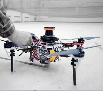
Image Caption: MIT researchers describe an autonomous system for a fleet of drones to collaboratively search under dense forest canopies using only onboard computation and wireless communication — no GPS required.
In a paper being presented at the International Symposium on Experimental Robotics conference next week, MIT researchers describe an autonomous system for a fleet of drones to collaboratively search under dense forest canopies. The drones use only onboard computation and wireless communication — no GPS required.
Each autonomous quadrotor drone is equipped with laser-range finders for position estimation, localization, and path planning. As the drone flies around, it creates an individual 3-D map of the terrain. Algorithms help it recognize unexplored and already-searched spots, so it knows when it’s fully mapped an area. An off-board ground station fuses individual maps from multiple drones into a global 3-D map that can be monitored by human rescuers.
In a real-world implementation, though not in the current system, the drones would come equipped with object detection to identify a missing hiker. When located, the drone would tag the hiker’s location on the global map. Humans could then use this information to plan a rescue mission.
“Essentially, we’re replacing humans with a fleet of drones to make the search part of the search-and-rescue process more efficient,” says first author Yulun Tian, a graduate student in the Department of Aeronautics and Astronautics (AeroAstro).
The researchers tested multiple drones in simulations of randomly generated forests, and tested two drones in a forested area within NASA’s Langley Research Center. In both experiments, each drone mapped a roughly 20-square-meter area in about two to five minutes and collaboratively fused their maps together in real-time. The drones also performed well across several metrics, including overall speed and time to complete the mission, detection of forest features, and accurate merging of maps.
Co-authors on the paper are: Katherine Liu, a PhD student in MIT’s Computer Science and Artificial Intelligence Laboratory (CSAIL) and AeroAstro; Kyel Ok, a PhD student in CSAIL and the Department of Electrical Engineering and Computer Science; Loc Tran and Danette Allen of the NASA Langley Research Center; Nicholas Roy, an AeroAstro professor and CSAIL researcher; and Jonathan P. How, the Richard Cockburn Maclaurin Professor of Aeronautics and Astronautics.
Exploring and Mapping
On each drone, the researchers mounted a LIDAR system, which creates a 2-D scan of the surrounding obstacles by shooting laser beams and measuring the reflected pulses. This can be used to detect trees; however, to drones, individual trees appear remarkably similar. If a drone can’t recognize a given tree, it can’t determine if it’s already explored an area.
The researchers programmed their drones to instead identify multiple trees’ orientations, which is far more distinctive. With this method, when the LIDAR signal returns a cluster of trees, an algorithm calculates the angles and distances between trees to identify that cluster. “Drones can use that as a unique signature to tell if they’ve visited this area before or if it’s a new area,” Tian says.
This feature-detection technique helps the ground station accurately merge maps. The drones generally explore an area in loops, producing scans as they go. The ground station continuously monitors the scans. When two drones loop around to the same cluster of trees, the ground station merges the maps by calculating the relative transformation between the drones, and then fusing the individual maps to maintain consistent orientations.
Page 1 of 2
Share on:


Testimonial
"We’re proud to call I-Connect007 a trusted partner. Their innovative approach and industry insight made our podcast collaboration a success by connecting us with the right audience and delivering real results."
Julia McCaffrey - NCAB GroupSuggested Items
Meet the Author Podcast: Martyn Gaudion Unpacks the Secrets of High-Speed PCB Design
07/16/2025 | I-Connect007In this special Meet the Author episode of the On the Line with… podcast, Nolan Johnson sits down with Martyn Gaudion, signal integrity expert, managing director of Polar Instruments, and three-time author in I-Connect007’s popular The Printed Circuit Designer’s Guide to... series.
Intervala Hosts Employee Car and Motorcycle Show, Benefit Nonprofits
08/27/2024 | IntervalaIntervala hosted an employee car and motorcycle show, aptly named the Vala-Cruise and it was a roaring success! Employees had the chance to show off their prized wheels, and it was incredible to see the variety and passion on display.
KIC Honored with IPC Recognition for 25 Years of Membership and Contributions to Electronics Manufacturing Industry
06/24/2024 | KICKIC, a renowned pioneer in thermal process and temperature measurement solutions for electronics manufacturing, is proud to announce that it has been recognized by IPC for 25 years of membership and significant contributions to electronics manufacturing.
Boeing Starliner Spacecraft Completes Successful Crewed Docking with International Space Station
06/07/2024 | BoeingNASA astronauts Barry "Butch" Wilmore and Sunita "Suni" Williams successfully docked Boeing's Starliner spacecraft to the International Space Station (ISS), about 26 hours after launching from Cape Canaveral Space Force Station.
KIC’s Miles Moreau to Present Profiling Basics and Best Practices at SMTA Wisconsin Chapter PCBA Profile Workshop
01/25/2024 | KICKIC, a renowned pioneer in thermal process and temperature measurement solutions for electronics manufacturing, announces that Miles Moreau, General Manager, will be a featured speaker at the SMTA Wisconsin Chapter In-Person PCBA Profile Workshop.