


 It’s Only Common Sense: Nice Guys Really Can Finish First
 The Right Approach: I Hear the Train A Comin'
 Marcy's Musings: The Growing Industry
Velodyne Lidar Sensors Power 3D Data Capture in New NavVis VLX Mapping System
May 13, 2020 | Business WireEstimated reading time: 1 minute
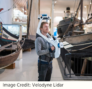
Velodyne Lidar, Inc. announced the NavVis VLX wearable indoor mobile mapping system, launched today, is equipped with Velodyne lidar sensors to provide high-quality data capture of 3D measurements. NavVis VLX is designed for reality capture in complex built environments such as construction sites and multi-level towers.
Each NavVis VLX system uses two Puck LITE™ sensors to capture point cloud data needed to create building documentation including floorplans, 3D models and digital twins. NavVis VLX combines Velodyne image data with NavVis simultaneous localization and mapping (SLAM) technology to deliver survey-grade point clouds with a mobile device. Its compact, versatile design enables the system to map small, fragmented and narrow spaces as well as environments with many obstacles and uneven terrain.
“Velodyne sensors provide real-time 3D data to our mobile mapping systems. This valuable input has played an important role in developing the industry-leading SLAM algorithms that power our flagship mobile mapping system, NavVis M6,” said Georg Schroth, NavVis CTO. “Now we are launching NavVis VLX, a complementary device that features the same ground-breaking SLAM technology in a compact, versatile design. We are very happy to have Velodyne be part of our efforts to provide laser scanning professionals with fast, efficient tools for scanning buildings that are capable of delivering survey-grade results.”
“NavVis mobile mapping systems capture the data needed for as-built documentation, such as 3D models and floorplans as well as realistic digital factories for enterprise manufacturing facilities. Stakeholders can inspect, document and share information about buildings and factories to track milestones, plan relocations and improve both customer and employee experience,” said Erich Smidt, Executive Director Europe, Velodyne Lidar. “The NavVis VLX system strongly demonstrates how the performance, range and compact form factor of Velodyne sensors enable companies to build innovative systems. The solution addresses specialized mobile mapping needs of AEC companies, surveyors and laser scanning professionals.”
Velodyne Puck LITE sensors deliver a high-resolution image to measure and analyze indoor and outdoor environments. Designed for applications that require a sensor with a low weight and compact size, the Puck LITE delivers outstanding resolution and performance for mobile and UAV/drone applications. It provides a full 360-degree environmental view to deliver real-time 3D data.
Share on:


Suggested Items
Boeing T-7A Red Hawk Triples Progress
05/01/2024 | BoeingThe Boeing T-7A Red Hawk achieved three recent milestones, propelling the advanced pilot trainer for the U.S. Air Force forward.
Merlin Flex invests in New Schmoll Direct Imaging System
04/30/2024 | Merlin Flex LtdMerlin Flex has fully installed and commissioned its 2nd Schmoll MDI Direct Imaging system. This new machine includes a twin bed, 4 head system which enhances Merlin Flex’s direct imaging capability for its 1.4M long flexible circuits.
Latest Test and Inspection Solutions from GOEPEL electronic at SMTconnect 2024
04/29/2024 | GOEPEL electronicGOEPEL electronic will be demonstrating automated test and inspection equipment at SMTconnect, taking place in Nuremberg from June 11 to 13, 2024.
TSMC Celebrates 30th North America Technology Symposium
04/29/2024 | TSMCTSMC unveiled its newest semiconductor process, advanced packaging, and 3D IC technologies for powering the next generation of AI innovations with silicon leadership at the Company’s 2024 North America Technology Symposium.
QinetiQ Achieves UK’s First Jet-to-Jet Teaming Between Aircraft and Autonomous Drone
04/29/2024 | QinetiQQinetiQ has successfully trialled the UK’s first Crewed-Uncrewed-Teaming demonstration between a crewed aircraft and an autonomous jet drone.