


 The Government Circuit: New Council Now Helps Shape Policy Decisions in the Electronics Supply Chain
 Learning With Leo: Soldering—The Interpretation Problem


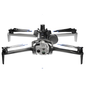
Skydio, the leading U.S. drone manufacturer and world leader in autonomous flight technology, today announced a strategic collaboration with Trimble creating an integrated workflow of accurate data capture, data visualization, and data analytics addressing the needs of critical infrastructure industries in their surveying, mapping, and inspections. This collaboration, currently in the developmental stage, will enable customers to benefit from centimeter-level accuracy in survey and mapping projects through the precise data capture, visualization, and analytics enabled by Skydio autonomous drones integrated with Trimble GNSS receivers and software.
Announced at Trimble’s annual user conference, Dimensions, the combination of the recently announced Skydio X10 autonomous drone with Trimble Construction Cloud will enable construction, and utility companies, as well as state transportation agencies to streamline workflows for greater precision and project efficiency. Autonomous drones, quadcopters with powerful visual and thermal camera sensors such as the X10, are relied on by industry leaders for their ability to capture real-time condition reports of critical infrastructure conditions. By capturing images and geospatial data early and often throughout construction projects, organizations can more easily ensure on-site work matches the design and reduce costly rework, which for the average project can easily be 4-6% of the overall construction cost. When bridge or utility site inspections need to scale, using the Skydio and Trimble integration delivers comprehensive data and workflow needed to identify issues early and take action to prevent failures.
“This collaboration brings together two leading companies and their innovative technologies to further revolutionize how we digitize and map our physical world,” said Gagan Kanwar, Skydio’s Head of Technology Partnerships. “By deepening product integration, organizations using Trimble and Skydio will benefit from survey-grade accuracy in mapping missions and go from data-to-insights that much faster.”
"Incorporating Skydio into our ecosystem augments our platform's capabilities, offering our customers a fully integrated, end-to-end workflow from data acquisition to analytics," said Aviad Almagor, Vice President of Technology Innovation at Trimble. “Our customers are seeking such automated workflows to handle the vast amount of data and maximize its value through improved production and quality control processes.”
Key benefits of the Skydio and Trimble collaboration include:
Automated Data Integration: An automated, API-based integration enables seamless transfer of drone-captured imagery and metadata from Skydio Cloud to Trimble Industry Cloud. This integration accelerates the conversion of reality-capture data into actionable insights that enable more efficient and shorter decision-making processes. Further refinement and analysis of the output data can be carried out in professional surveying and mapping environments such as Trimble Business Center (TBC).
Survey-Grade Accuracy with Skydio X10: Skydio's flagship X10 drone with the RTK GPS attachment will be fully compatible with Trimble's GNSS receivers, enabling mutual customers to achieve survey-grade accuracy in mapping missions when employing Skydio alongside Trimble's base stations and GNSS receivers. Beyond RTK, customers will also be able to conduct PPK based corrections post-flight.


